
|
|
|
The Land
The westernmost of Canada's three Prairie provinces, Alberta lies between the
49th and 60th parallels, at virtually the same latitude as the United Kingdom.
Alberta is 1217 km from north to south and between 293 and 650 km in width from
west to east. Nearly equal in size to the state of Texas, the province covers an
area of some 661 185 km2.
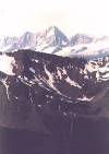
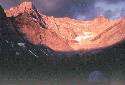
Roughly half of the southwestern section of the province is dominated by mountains and foothills - striking reminders of the glaciers that, over millions of years, formed, moved and receded in the area. Peaks of the Rocky Mountains located in Alberta range from 2130 to 3747 m in elevation.
The foothills, which form a gentle link between mountain and prairie landscapes, feature heavily forested areas and grasslands used for grazing cattle. Beneath their surface, the foothills contain some of the province's richest deposits of sour gas and coal.
The remainder of the province - approximately 90 percent of the land area - forms part of the interior plain of North America. The plains include the forested areas that dominate the northern part of the province and the vast stretches of northern muskeg that overlay much of Alberta's oil and gas deposits and oil sands.
Alberta has what is known as a continental climate. It is characterized by vivid seasonal contrasts in which long, cold winters are balanced by mild to hot summers and an unusually high number of sunny days, no matter what the season. Although cold air covers the whole province in winter, it is frequently replaced in the southwest by a mild wind, the "chinook," funnelling through the mountains from the Pacific Ocean.
Alberta is a Province situated near the Canadian Rocky Mountains and has a spectacular mountain scenery. Here are a few samples:
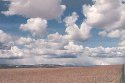
It is also a Province that contains large open plains and skies:
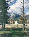
Here is a picture of a typical Indian residential area:
![]()
